A new online map tool allows Americans to see whether they can easily meet their essential needs without getting a car — and advocate for their cities to cultivate the walkable amenities that are missing, as well as create safe routes to reach them.
Developed by Here Technologies, a digital mapping company, the 15-minute city app is an elegant tool that helps average people understand just how car-dependent their neighborhoods really are by helping them visualize which daily necessities they could easily reach in a 15-minute walk, bike, or wheelchair trip — including grocery stores, doctors offices, parks, and more. French academic and Sorbonne professor Carlos Moreno introduced the "15 minute neighborhood" concept as a forward-thinking measure of livability and sustainability; Paris mayor Anne Hidalgo later seized on it, and has worked towards transforming the City of Light into a collection of human-scaled neighborhoods throughout her time in office.
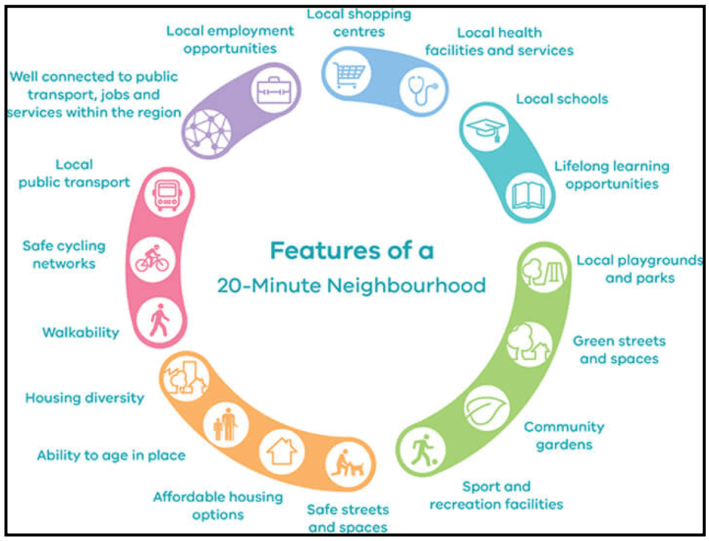
Of course, most of us already know whether or not we have to climb in a car to catch a movie or visit a local library. But Here Technologies' app provides some crucial insights about whether our neighbors' most urgent needs are being met by the surrounding area — and what the lowest-hanging fruit might be when crafting a plan to make car-free living a real option for more people.
The average college student, for instance, may get by just fine on foot in a neighborhood populated with trendy restaurants, bars, and a few grocery stores, but the single mom next door might be drowning under the costs of maintaining a car that she needs to get her kid to the closest elementary school miles away. A low-vision person on the same block, meanwhile, might struggle to access a simple park without the help of a sighted driver to take them a few miles down the road, while a twenty-something with 20/20 vision is happy to ride her bike to the same park.
Here's app can help empower those with significant privilege — or simply different needs than their neighbors — to advocate not just for neighborhood amenities that meet their own needs, but for those that many others are likely to rely on. That's a crucial ingredient to ending broad car dependence that often goes under-discussed among those whose only significant barrier to biking and walking is the prevalence of dangerous car traffic.
"We [focused on] walking verses driving to highlight the spatial contrast across American communities," said Jordan Stark, a representative for the company. "This is the starting basis for new map tools and data to lay bare gaps in mobility, equity and access."
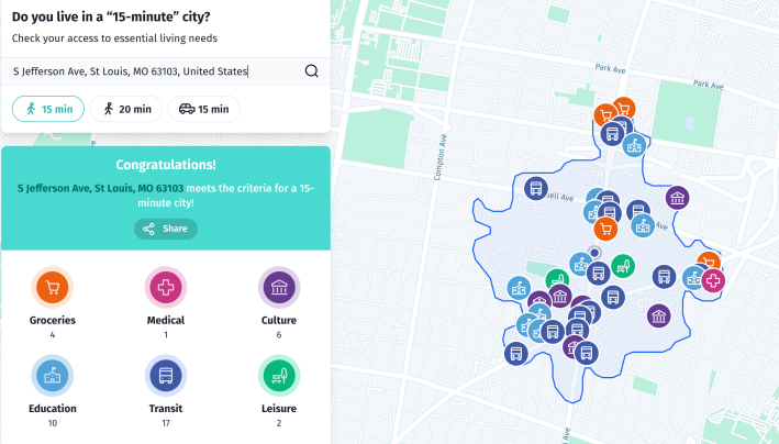
Stark knows the beta version of the 15-minute city map isn't perfect, and says the company has plans to enhance it in the future.
Most notably, the app doesn't yet provide information on which routes are safe to walk, bike, or navigate in a wheelchair, rather than simply possible to travel without a car. My St. Louis neighborhood, for instance, technically meets the 15-minute city criteria, but it doesn't point out that the only full-scale grocery stores on the map — both of which are located in the farthest reaches of the neighborhood radius — are situated just past a major highway underpass whose narrow sidewalk is insufficient in the best of times, but has become virtually impassible for months thanks to an ongoing construction project.
Overlaying the map with data from the many apps that score local roads for non-driver safety could go a long way to show city leaders which neighborhoods can really claim the 15-minute city title, and which still have a ways to go. So could enhancing the app's search functions to distinguish between amenities that are useful to a lot of people — say, a walk-in community health clinic that accepts patients without insurance — versus amenities that are more specialized — like a podiatrist's office that hasn't taken new patients in years. (No, even the biggest evangelists of the 15-minute city concept don't think putting 'a world class cancer treatment center on every corner' is necessary to make cities accessible.) And of course, the map may never be able to easily help users visualize some of the less easily-mapped barriers to mobility without motor vehicles, like the threat of state violence to people of color in over-policed neighborhoods, or the threat of COVID-19 transmission on sidewalks that become crowded by pedestrians during peak commute times.
But the Here Technologies app still provides a fantastic starting point for the conversation about what it means to build car-optional places, beyond simply building generous sidewalks and shortening crossing times on roads that lead nowhere. And if we want to make our neighborhoods truly walkable and rollable, we would be wise to look for ways to build on its insights locally.
