Skip to Content
Streetsblog USA home
Log In
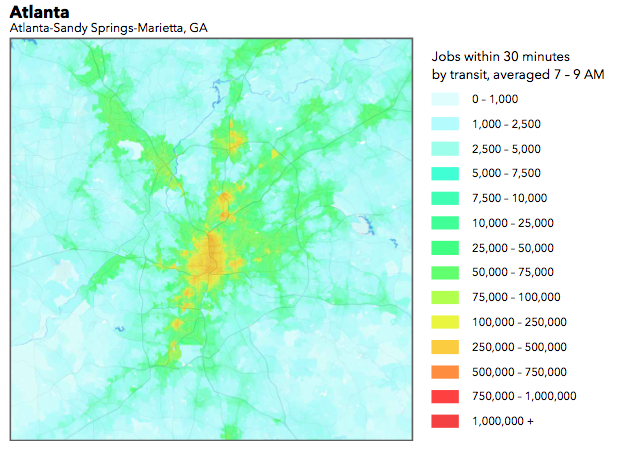
This chart shows the number of jobs accessible by transit in Atlanta. Red indicates better accessibility by transit. Image: University of Minnesota
This map shows the number of jobs accessible by transit from a given point. Few parts of Atlanta have good transit accessibility compared to the nation's top performing cities. Map: University of Minnesota
This chart shows the number of jobs accessible by transit in Atlanta. Red indicates better accessibility by transit. Image: University of Minnesota

It's been called "the geography of opportunity." And David Levinson is trying to make a science of it.

In a new analysis, Levinson, a University of Minnesota transportation engineering professor, and his colleague Andrew Owen have ranked the 50 largest U.S. metro areas based on job accessibility by transit [PDF].

Levinson and Owen used transit schedules and walking routes to chart how many jobs are accessible in each region from a given point within a given amount of time. Adding Census data about where people reside, they were able to calculate the number of jobs the average worker in each region can reach via transit within 10-minute intervals. The rankings are based on those stats -- the more jobs a typical resident can reach via transit in a short amount of time, the higher a region performed.
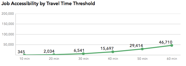
This chart shows job accessibility by 10-minute intervals for the Charlotte region. Image: University of Minnesota
This chart shows the number of jobs accessible via transit for an average worker in the Charlotte region, within 10-minute intervals of travel time. Graph: University of Minnesota
This chart shows job accessibility by 10-minute intervals for the Charlotte region. Image: University of Minnesota

The top 10 cities for job accessibility by transit, according to Owen and Levinson, align fairly well with what you would expect:

    1. New York City
    2. San Francisco
    3. Los Angeles
    4. Washington
    5. Chicago
    6. Boston
    7. Philadelphia
    8. Seattle
    9. Denver
    10. San Jose

The authors said these cities tend to have two things in common: "a combination of density and fast, frequent transit service."
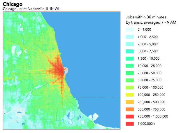
Chicago's job accessibility by transit, mapped. Image: University of Minnesota
Chicago's job accessibility by transit. Map: University of Minnesota
Chicago's job accessibility by transit, mapped. Image: University of Minnesota

Meanwhile, mid-level performers like Atlanta (#30) combine decent transit systems with very low density and a high level of job sprawl. The very worst performers were sprawling -- many are concentrated in the Southeast -- and had weak transit systems to boot.

The 10 worst regions for accessibility by transit, in descending order, are Kansas City, Indianapolis, Austin, Raleigh, Cincinnati, Orlando, Nashville, Virginia Beach, Riverside, and Birmingham. Some cities, including Oklahoma City, Memphis, Jacksonville, and Richmond, were not ranked due to a lack of transit data.

It should be noted that even in cities at the top of this ranking, transit access to jobs remains poor for many people. For the average Chicago resident, for example, a meager 7.3 percent of jobs are accessible within a 60-minute transit trip. That only looks good in comparison to cities like bottom-of-the-pack Birmingham, Alabama, where the same figure is just 3.3 percent.


Stay in touch

Sign up for our free newsletter

More from Streetsblog USA

Do Tuesday’s Headlines Live in a 15-Minute City?

Find out how long it takes to walk to stores, restaurants and transit stops in your neighborhood with this Washington Post widget.

December 10, 2024

Even at Slower Speeds, SUVs and Pickups are a ‘Big’ Problem for Pedestrians

Pedestrians hit by median-height cars have a 60 percent chance of suffering moderate injuries, but that figure rises to 83 percent when they are struck by a median-height pickup truck at that same speed.

December 10, 2024

Can We Build Car-Light Neighborhoods From Scratch — Even in Texas?

Can you really build a car-light neighborhood in suburban Houston — and could it inspire car-dependent places to explore new ideas about development?

December 10, 2024

How Trump’s Mass Deportation Plans Could Make U.S. Roads More Dangerous

President-elect Trump's promise to deport one million people per year will make America's streets less safe.

December 9, 2024

The Buck Stops With Monday’s Headlines

Harry Truman was known for whistle-stop campaigning, and interstates are associated with Eisenhower. But that's not entirely true, as the Eno Center explains.

December 9, 2024
See all posts