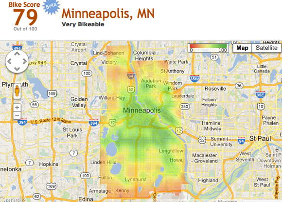
The people behind Walk Score, the real estate rating service that goes by the slogan “Drive Less, Live More,” are out with a new rating system, based on hard data, that should prove useful to prospective city dwellers: Bike Score.
The company launched the Bike Score website today, using its new algorithm to rank the ten most bikeable cities in the country. (We covered their release of city rankings for transit last month.) Minneapolis ran away with the top prize with a 79 percent bikeability rating. San Francisco tied Portland for number two, despite the fact that hilliness was a factor. D.C. and New York also placed highly (while the NYC core rates very highly on Bike Score, the bike lane deserts outside the center city score quite low).
In other bikeability rating news, the League of American Bicyclists released its 2012 list of Bicycle Friendly Communities today. There’s a lot of overlap between the BFCs and the Bike Score winners, but they are compiled use vastly different methodologies. For one thing, you won’t find two of the League’s top three cycling cities on the Bike Score list because Bike Score, so far, only looks at cities with populations over 200,000. Sorry, Boulder and Davis.
Colorado and Montana did well in the League’s rankings this year. Missoula and Durango moved up to gold, and the Colorado towns of Gunnison and Aspen made it onto the list for the first year, rolling in at the silver level. Look for your city on their updated BFC list [PDF].
The League bases its BFC choices on somewhat subjective criteria. They look for the “five Es”: engineering, education, encouragement, evaluation & planning, and enforcement. Decisions are made by staff and external reviewers, in consultation with local stakeholders.
Bike Score, on the other hand, is based on pure numbers. Individual addresses are rated on a scale of 0-100 based on four factors:
- the availability of bike infrastructure (with on-street and off-street facilities weighted differently)
- the hilliness of the area (the one factor a city can’t control)
- amenities and road connectivity
- the number of bike commuters (because “biking is social” and there’s safety in numbers, explained Walk Score's chief technology officer and co-founder Matt Lerner)
To then determine the score for the city, the individual address scores are used to compute scores for each block, and then the block-by-block scores are weighted by population density.
“For every location in the city, we add up the number of meters of bike lane, and there’s a distance-to-K function so the closer you have a meter of bike lane, the more valuable it is, and we don’t give you any credit after about a mile out,” said Lerner. “For every address, we do that calculation. It’s a new metric that is really about a specific location, not about the city overall. So what we’re really measuring is, for average person in that city, how good is biking.”
Note: The capability to score your own home isn’t available on the website yet, as it is for Transit Score and Walk Score, but Lerner says they hope to enable that soon so real estate agents can use Bike Score to advertise the homes they have for sale, as they do now with the other two. Walk Score has an Apartment Search function that allows renters to search by nearby amenities, distance to transit, commute time, price, number of bedrooms – and, of course, Walk Score. It interfaces with craigslist to show the complete ad all in one place with the walk/bike/transit information.
Right now you can plug in any address in the country and get a Walk Score for it, but even once Bike Score’s full functionality is rolled out, it won’t be so widespread. “With Bike Score we have to go out and get bike lane data from each city,” Lerner said, “so it’s more of a manual process.” They’re taking votes via Twitter for the next cities they should score.
