Can This Tool Predict Where Your City’s Next Car Crash Will Happen?

A new tool that marries artificial intelligence and hard crash data could help decision-makers pinpoint exactly where crashes are most likely to happen — and make changes to prevent traffic violence before the next person dies, its developers say.
Last September, Cambridge Mobile Telematics announced the release of StreetVision, which the company claims is “the first AI road safety platform that predicts and prevents crashes.”
While not exactly a magic crystal ball, the company says it works by combining AI insights from cell phone users with government crash data to identify likely future hot spots and model the potential impact of life-saving strategies. And the architects of the tool say its bold claim is already proving true.
In the last six months, departments of transportation in New Mexico, Massachusetts, Ohio, Texas, and others have begun relying on StreetVision to help decide where they should install things like roundabouts and speed cameras, confirm whether those strategies work, and build the case for more of them. The company is also giving select advocates backstage access to the universe of granular data it has compiled on American motorists, which can help them make the case for bold policies, too.
“We’re basically bridging the past with the future,” said Ryan McMahon, the company’s senior vice president. “We’re taking that expertise, and bringing it to a place [where decision-makers] can do a heck of a lot more with it.”
McMahon explained that motorists have been volunteering their anonymized, aggregated cell phone data to companies like Cambridge for years in exchange for discounts on their car insurance for safe driving.
Today, with 55 million drivers doing that — or roughly one in five U.S. license-holders — the company has built a robust dataset for transportation officials to quickly take the temperature on trends like cell phone distraction, hard-braking, and speeding. Actuaries say all those behaviors are highly predictive of future collisions, particularly when they happen again and again at the same sites.
Before the era of Big Data, though, DOTs had to wait months or years for official reports on the tiny subset of motorists caught for those disturbingly common behaviors — or worse, who got in a crash before they were caught. And even when those crashes did repeatedly happen in similar roadway environments, they often weren’t happening enough for analysts to confidently say that future crashes were statistically likely, even as death totals swelled to predictably terrifying proportions.
“If you look at the history of road safety, the denominator for [whether roads are safe] has just been, for the most part, looking at crash records,” added McMahon. “You’re talking about more than 40,000 people [dead every year], year after year. It’s terrible. But the reality is, from a predictive modeling standpoint, even that crash by itself is not predictive enough to predict the next crash.”
Millions of predictive data points from cell phones, though, aren’t always enough on their own to justify installing expensive countermeasures, either — at least not according to government documents like the Manual of Uniform Traffic Control Devices.
That notorious guidebook has been criticized for relying on retroactive “crash warrants,” or a specified threshold of fatal or serious collisions over a certain period of time, to recommend when roads should be eligible for things like crosswalks or traffic lights. Some advocates say officials should be proactively installing those things before anyone else gets hurt, even as they recognize that making the case for those interventions can be an uphill battle without good data.
By combining crash data with cell phone stats in one place, though, McMahon says StreetVision can functionally predict where traffic violence will happen — or at least, reveal which roads are so bad today that we’d be senseless not to take action to improve them tomorrow.
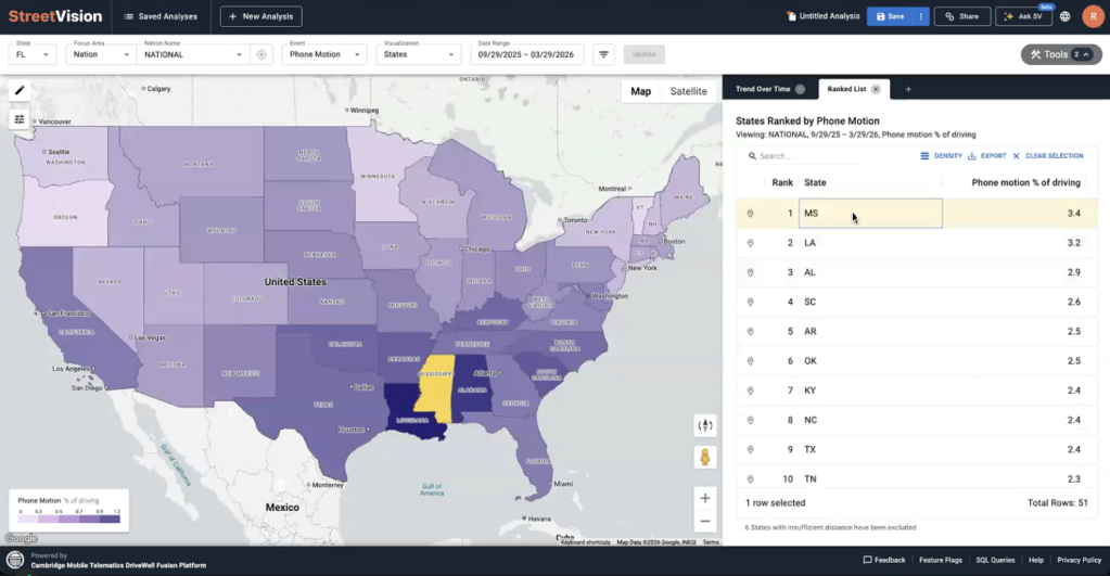
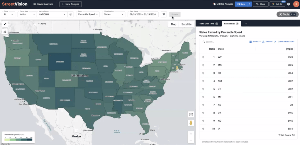
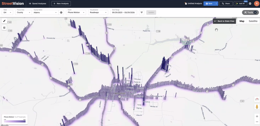
In a few clicks, for instance, the tool can calculate what percentage of drivers in Rhode Island were speeding last year, and which specific counties had the worst offenders. A few more, and it shows the specific block in Providence where the highest proportion of motorists had to suddenly slam on the brakes in the last month. Another click, and the tool connects to a Google Street View image of that very block, which might reveal a stop sign covered by overgrown trees.
The tool delivers also fascinating big-picture insights, like the fact that drivers in Mississippi are the most distracted in the nation, spending a stunning 3.4 percent of their time behind the wheel actively manipulating their phones. That’s excluding anytime a car was moving less than 10 miles per hour, and anytime the phone was being held by a passenger or transit rider, which the company says it can automatically filter out.
All those insights can provide a more detailed picture of the role of distraction in our car crash epidemic than official reports show — though StreetVision visualizes those reports, too. Based largely on the estimation of law enforcement, NHTSA estimates that just 8 percent of car crash deaths involve a driver who was using their cell phone, but McMahon suspects the real number is far higher.
“Really, in about one-third of crashes, the driver’s phone is in their hand a minute prior to the crash,” he adds. “[But] distraction really hasn’t been part of the conversation, at least not relative to the impact it’s had. StreetVision is giving a tool to those who are in a position to change things, to have the conversation at the state legislature [about implementing countermeasures]— and then once they’re implemented, to look and see how that changes over time.”
McMahon is careful to note that StreetVision itself doesn’t actually tell transportation officials what to do with all this information to save lives — nor should it. But it can validate human leaders’ actions once they’ve made a choice, and help make the case for increased safety spending.
Flagstaff, Arizona, for instance, converted a signalized intersection into a roundabout after crashes there began to mount, and managed to reduce hard braking by 24.5 percent and phone distraction by 14 percent; thanks to StreetVision, the city discovered that drop-off in a matter of weeks, without an expensive formal traffic study. Kenmore, Washington, meanwhile, managed a 30-percent reduction in speeding after it installed speed cameras in school zones, all within just two weeks of implementing 24/7 enforcement.
When safety dollars are scarce — and they are almost everywhere — McMahon says big data can help identify where spending them will make the most impact. In Ohio, for instance, StreetVision helped reveal that a new hands-free cell phone law was struggling to influence drivers in counties that bordered Kentucky, which doesn’t have a similar anti-distraction policy on the books. That meant that the state DOT could consider spending less on public awareness campaigns in the middle of the state, and concentrate its dollars on the specific roads where people still needed a reminder.
It’s easy to imagine other applications for the technology, too — particularly when it comes to saving pedestrian and cyclist lives.
“If you’re trying to build a highway safety plan that is addressing distraction around vulnerable road users, you could just simply go to the intersection feature, build a ranked list, and then just start targeting those areas one by one, instead of waiting for crashes to occur,” McMahon added.
Of course, many U.S. communities might not take action to stop traffic violence even if they had a perfect crystal ball to predict where the next deadly motorist would strike — and StreetVision doesn’t claim to be able to see the future.
Still, in a world where political inertia and moneyed special interests have combined to stop progress on Vision Zero in too many communities, McMahon hopes that tools like his can shine a light on the need to take action — and provide an example of how AI can be used for good.
“There’s no automated decision-making. There’s no automated changes to the infrastructure or the environment. There’s simply more information to help individuals make better decisions,” McMahon adds. “[And it] doesn’t take somebody getting into a crash to do that.”

Read More:
Streetsblog has migrated to a new comment system. New commenters can register directly in the comments section of any article. Returning commenters: your previous comments and display name have been preserved, but you'll need to reclaim your account by clicking "Forgot your password?" on the sign-in form, entering your email, and following the verification link to set a new password — this is required because passwords could not be carried over during the migration. For questions, contact tips@streetsblog.org.