This App Could Make D.C. One of the Most Accessible Transit Networks In the World
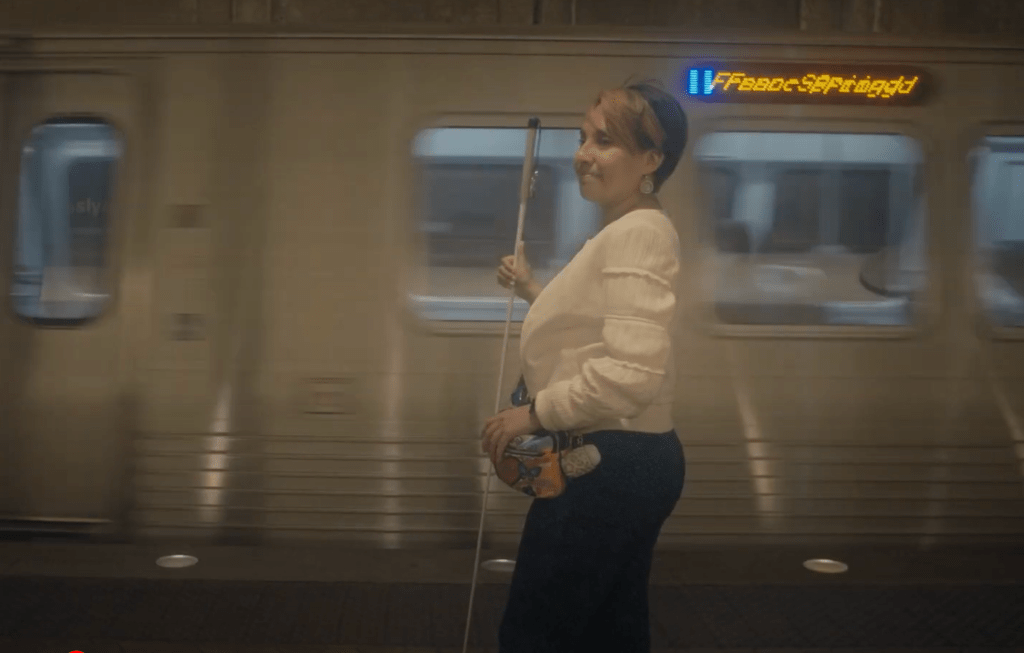
A groundbreaking new app will make it possible for people with visual impairments to navigate every transit stop in the nation’s capital — and its founders hope it will spark a deeper conversation about how technology can help everyone choose shared modes with confidence and ease.
After a successful two-year pilot in which developers mapped roughly 100 rail stations, 11,000 bus stops, and 325 distinct bus routes and the roads leading up to them for a range of accessibility needs, officials at the Washington Metropolitan Area Transit Authority announced today that riders could now use the Waymap navigation app across its entire network, including underground stations that traditional GPS and WiFi-based services can’t always reach.
That might make Washington, D.C. the first entire city and transit network in the world to be 100 percent navigable on a smartphone, even in the deepest reaches of its underground.
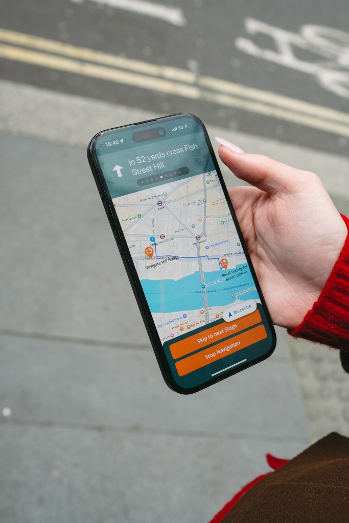
Relying on motion sensors inside the phone itself rather than signals from satellite or bluetooth beacons – and free to use for riders, to boot — Waymap bills itself as the first and only indoor mapping service that requires no external infrastructure to work. More importantly, though, the founders hope it will serve as a missing link between the millions of unique members of the disability community and true mobility independence, supplying turn-by-turn audio and visual navigation cues that can be customized to the specific person using them.
And along the way, it could help give other riders the extra boost of confidence they need to try transit, too.
“We started out very clearly with an objective of inclusive design, which means ‘nothing about us without us,'” added founder and president Tom Pey. “And one of the things that we learned was that dedication to that principle comes at a cost of speed sometimes. … [But] the demand from the stakeholders with whom we’ve engaged has been really encouraging, and that’s kept us going at times when the going got tough for us. And now, we have a product that is really going to raise the roof.”
Pey lost his sight 30 years after he fell off a roof as a child and contracted a rare form of blood poison from a cut he sustained on the way down, which gradually damaged the vessels that bring oxygen to his retina. As his sight eroded, he says his life shrank from a world of “infinite” possible routes to just a handful of well-known paths near home — and that he’s heard stories from countless others whose worlds contracted drastically after a disability diagnosis, too.
Later, as CEO of the Royal Society for Blind Children, Pey met young people who had lived with disabilities from birth, and had never experienced the freedom of being able to confidently go out by themselves, particularly on London’s famous Underground.
Those stories were what inspired Pey to found Waymap, and eventually, to bring it stateside — and the stories of the people it’s helped in D.C. have motivated him to keep expanding the product’s reach. One of those beta testers, Evelyn, was a particular motivation.
“She’s no shrinking violet,” Pey said. “She’s an up-and-at-it lady who uses Waymap and finds that it has changed her life. She goes out with confidence knowing that she’s going to get to the place she wants to go to and she’s going to get home. These people are saying that we’re trailblazing for them, because Waymap has gone before them to tell the routes to get to a particular place and how to get back. That really increases their confidence.”
Of course, people with visual impairments aren’t the only ones who don’t feel particularly confident using America’s transit networks, which can sometimes feel like a daunting puzzle with half the pieces missing — especially if way-finding signs or network maps are confusing or difficult to find. For people visiting unfamiliar cities or who simply haven’t ridden the bus in a while, studies show that intimidation might be enough to motivate someone to take a car instead.
Waymap’s founders say they will always put the needs of the blind community first and foremost, but their pilot had the happy side effect of making their app customizable to the needs of for anyone who needs a little help navigating D.C.’s roads and tunnels.
Users can request routes that avoid stairs, escalators, and elevators, for instance, or ask the app to send them alerts about the exact location of wheelchair ramps before they leave the house and find themselves stranded without one. They can fine tune the speed and pitch of audio alerts to match their preferences and cognitive needs, as well as switch between four different languages. And if they’re walking, the algorithm will even learn their unique stride length and tell them exactly how many steps they’ll take before they’ll make their next turn.
Someday, Waymap might even help a transit rider navigate all the way from the bus to a specific site inside her destination, without ever needing to leave the app. The company is already in talks to map the interiors of complex destinations like grocery stores, hospitals, museums and sports arenas, so people with disabilities can get exactly where they’re going on their own.
“A lot of people ask us, ‘When will it be done?'” said Celso Zuccollo, Waymap’s CEO. “The answer is, it’ll never be done, because everybody requires something slightly different.”
Of course, an app alone won’t make D.C.’s transit network 100 percent accessible. Even if Waymap can let a rider know exactly where to find an elevator at her train station, it certainly can’t deliver the funding necessary to keep it in working order, or the political will to build curb cuts and install tactile pavers everywhere that travelers need them, as well as a universe of other challenges that people with disabilities might face as they travel.
Still, both Pey and Zuccollo hope their app can be another tool in agencies’ accessibility arsenal, even as they fight for broader change. And with pilots underway in the UK, Australia, Singapore, Spain, and Los Angeles, they hope Waymap technology will soon become a basic component of the way transit agencies operate — particularly in America, which they credit with launching the disability rights movement worldwide.
Despite Washington’s recent disturbing attacks on accessibility and inclusion, they hope the success of their product in White House’s backyard will help cut through the noise.
“Policies come and policies go around the world, but we won’t change what we’re doing,” Pey added. “We started out with a vision to make the world accessible for everybody, and to help build an inclusive community. And I still think that, politics not withstanding, everybody wants that.”

Read More:
Streetsblog has migrated to a new comment system. New commenters can register directly in the comments section of any article. Returning commenters: your previous comments and display name have been preserved, but you'll need to reclaim your account by clicking "Forgot your password?" on the sign-in form, entering your email, and following the verification link to set a new password — this is required because passwords could not be carried over during the migration. For questions, contact tips@streetsblog.org.