There’s a Flat Bike Network Hiding in Your City, If Someone Would Build It
There’s no doubt: Hills are a problem for bike transportation. Which is why one company’s concept for removing the hills from a city has such promise.
This short video comes from Lisbon, Portugal, a city built on “seven hills.” It’s made by a firm called Horizontal Lisbon, which makes the intriguing promise that it’s discovered how to make the city horizontal:
The secret: finding a bikeable city threaded through the familiar one.
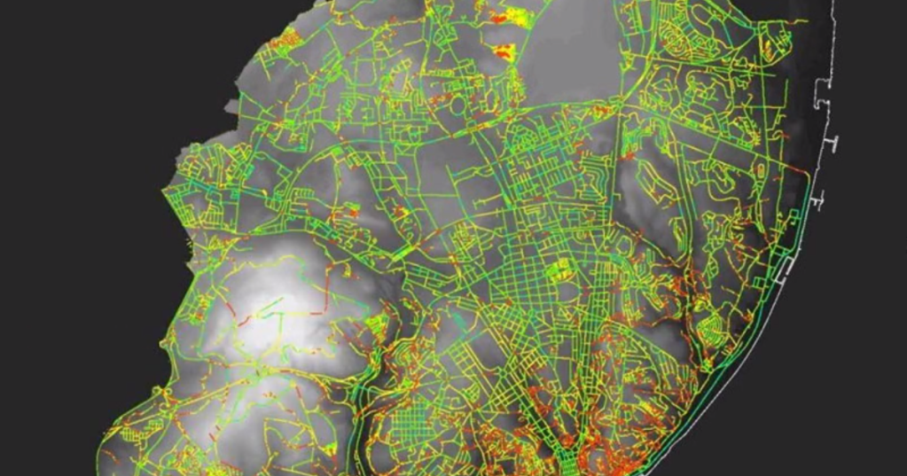
Horizontal Lisbon mapped 1,093 kilometers of city streets, it explains. Then it calculated the incline of every single one:

Of those, 691 kilometer have grades of no more than 4 percent — suitable for relatively low-impact biking. (For comparison’s sake, that’s about half the maximum 8.33 percent grade allowed by the Americans with Disabilities Act for bridges and access ramps.)
Using its new maps of the city’s flattest 63 percent of streets, Horizontal Lisbon then identified a series of relatively flat bike routes, assigning a color to each one as if it were a subway line. This maps one of the routes and its feeder streets in yellow:


And here’s green:


The suggestion of using color to independently brand different bike routes is novel, but seems appropriate for the winding paths these routes would need to take through the city.
Horizontal Lisbon’s concept has mostly just been marketing for their mobile app, which helps people choose flat routes to bike on.
But there’s a broader lesson here for any city that wants to build for biking. Street maps are not enough to know if a network works. To serve people who haven’t built up thighs of iron, cities should calculate which streets are flat and assign particular importance to getting safe bike routes on those streets.
In many U.S. cities, this will mean running protected bike lanes on one-time streetcar routes that remain commercial corridors today. Topography, after all, has been shaping our cities since their beginning.
As Horizontal Lisbon shows, computers may be useful for this job. But considering the contours of the land as we plan our transportation system isn’t really a high-tech innovation. It’s more like a forgotten skill.
PlacesForBikes is a PeopleForBikes program to help U.S. communities build better biking, faster. You can follow them on LinkedIn, Twitter or Facebook or sign up for their weekly news digest about building all-ages biking networks.

Read More:
Streetsblog has migrated to a new comment system. New commenters can register directly in the comments section of any article. Returning commenters: your previous comments and display name have been preserved, but you'll need to reclaim your account by clicking "Forgot your password?" on the sign-in form, entering your email, and following the verification link to set a new password — this is required because passwords could not be carried over during the migration. For questions, contact tips@streetsblog.org.