The Link Between Northeast Ohio's Flooding and Its Sprawl
After a string of major flooding events, residents of Northeast Ohio are looking for someone to blame, reports Tim Kovach. Are local governments at fault for the property damage from these floods? Or should residents, as a great poet once said, blame it on the rain?
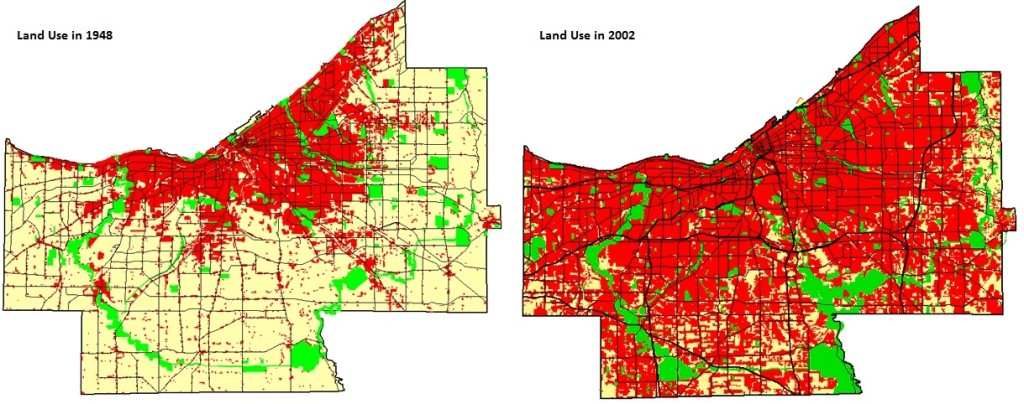
Neither question really gets to the heart of the matter, says Kovach. If Northeast Ohio hadn’t spent the last 60 years spreading out ever farther, covering huge areas with impermeable pavement and developing every last inch of land, then the region would be much more resilient in the face of torrential storms, he writes:
…a recent study out of the University of Utah suggests that from 2000-2010, the Cleveland metro area became even more sprawling (PDF). Using Smart Growth America’s sprawl index, the authors examined the rate of change for the 162 largest metro areas (paywalled) during this period. While Akron actually became 2.7% more compact, Cleveland sprawled by another 13.3%, the 10th worst change of any metro area…
So why does this all matter for flooding? Well, simply put, areas that follow sprawl-based development models are more likely to suffer from flooding problems. Sprawl increases the percentage of land area that is covered with impervious surfaces, such as parking lots, roads, and driveways. As the extent of impervious surfaces rises, so too does the amount of precipitation that winds up as surface runoff during storms. Forested areas are excellent at controlling stormwater (PDF); trees enable 50% of precipitation to infiltrate the soil and allow another 40% to return to the atmosphere through evapotranspiration. Urbanized areas, in contrast, drastically reduce the amount of water that can infiltrate into the soil, guaranteeing that 35-55% of precipitation ends up as runoff.
As Hollis (1975) has shown, urbanization increases the incidence of small flooding events 10-fold (paywalled). Additionally, if 30% of the roads in an urban area are paved, major flood events with return periods of 100 years or more tend to double in magnitude. Northeast Ohio has more than 48,000 acres of impervious surfaces, equivalent to approximately one-third of the region’s land area. Accordingly, we fall directly into that danger zone for major flood events due, in large part, to our development patterns.
Secondly, because so much of the county is already developed, many new developments are being built in existing flood zones. In December 2010, FEMA released its first comprehensive flood zone maps for Northeast Ohio since the 1960s. Unsurprisingly, these maps show a dramatic increase in the number of people living in flood zone areas, due to the outward expansion of development. Thousands of people woke up one day to find out that they had been living in a flood zone, and they were none too happy to learn that they would now have to shoulder some of the cost of that decision by purchasing federal flood insurance. Interestingly, the gentleman who filed the class action lawsuit against Strongsville over the flooding lives in a housing development in one of these flood plains.
Elsewhere on the Streetsblog Network: Seattle Transit Blog weighs in on proposals to expand and adjust the Sound Transit network. Dave Alden at Vibrant Bay Area goes back 13 generations to explain why he’ll be voting for a sales tax hike to fund infrastructure maintenance. And UrbanReviewSTL ruminates on what else you could do with all the land gobbled up by urban interchanges.

Read More:
Streetsblog has migrated to a new comment system. New commenters can register directly in the comments section of any article. Returning commenters: your previous comments and display name have been preserved, but you'll need to reclaim your account by clicking "Forgot your password?" on the sign-in form, entering your email, and following the verification link to set a new password — this is required because passwords could not be carried over during the migration. For questions, contact tips@streetsblog.org.