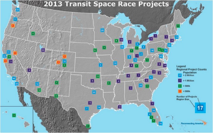
By the looks of it, my humble hometown of Washington, DC is winning the transit space race. The region currently has 45 transit projects either planned or underway -- and one that's stalled. You may have heard of the Silver Line to Dulles Airport, but a new map from Reconnecting America proves that that's just the tip of the iceberg when it comes to transit starts in the DC area.
Every year, Reconnecting America comes out with a map showing the "Transit Space Race" for that year, with all the fixed-guideway projects that are in any phase of realization, from a "twinkle in the eye" to under construction. (Cheers to RA for declining to accompany the release with a long-winded report that would just repeat what is plain to see in this simple, easy-to-use map.)
"The 2013 edition of the map identifies 721 projects in 109 regions, up from 643 projects found in 109 regions in 2011," the press release says. Then it seamlessly, almost coyly, meanders its way to the real point of the project: to illustrate the desperate need for more federal transit funding.
"Of the current projects, 497 have a cost estimate," RA says. "The total required to build just those 497 projects would be $250 billion. At the current rate of federal transit investment, it would require more than 78 years to construct those projects."
The MAP-21 transportation bill authorizes just under $10.6 billion for transit this year. Next year it goes up -- to $10.7 billion. Of that, just $1.9 billion is for transit New Starts, or system expansion.
Yonah Freemark recently published a similar map on the Transport Politic, highlighting projects beginning construction or entering service in 2013. Reconnecting America's map includes projects that don't have an opening date. It shows members of Congress who may think that there's no demand for transit in their districts that their constituents do, indeed, dream of it -- even if those dreams haven't yet become reality. It shows the enormous demand for fixed-guideway transit expansion, all over the country, in cities large and small.
"This list should be seen as a snapshot in time, which gives us a window into the magnitude of the need for greater funding and cooperation locally, regionally, and at the federal level," said Jeff Wood, RA's chief cartographer and lead author of the Space Race reports.
According to Reconnecting America, fixed-guideway projects on the map include heavy rail, commuter rail, light rail, streetcars, various technologies such as cog railways, and those bus rapid transit lines that have more than 50 percent of their right-of-way dedicated to bus-only lanes. The map does not include statewide projects such as the California high-speed rail effort.

