There's a map for that.
A commuter train, subway and bus app is launching an update to allow users to prioritize safe bike routes — but the tech company needs you to help make sure the information is up to date and accurate.
Go Bike, from Montreal-based company Transit, now allows users to make biking their first mode of transit, shows safer bike routes first, and provides multiple bike route options.
"We really wanted to ramp up our biking information in the app,” said Stephen Miller, the company's policy lead. “Obviously we are used for public transit, but it also means being able to walk and bike and make these types of connections.”
In a blog post announcing the change, Transit put it this way: "For years, biking has been a supporting actor within our app. Now, its face is on the movie poster.
The pandemic and the subsequent bike boom exposed what many advocates already knew — that cycling is a viable and cheaper transit option and a way to get people out of cars. And many companies are pushing to find ways to make biking safer and more accessible for people. Navigation tools are part of that ecosystem.
Companies like Apple and Google have had hiccups and complaints about their navigation apps for cyclists, and while they have made improvements, there’s still a pathway for other competitors to create or improve their navigation services for users.
For many riders, one of the first obstacles can be finding a safe route for travel.
“People aren't going to bike if they don't feel like there's a safe place to get to work without having a scary or unpleasant experience on a busy road,” said Colin Browne, spokesperson for the Washington Area Bike Association.
And for others, just general navigation routes for cyclists can make the difference. “‘How do I figure out how to get somewhere?’ is actually a question that we hear a lot,” Browne said.
Bike information has been available since 2017 on the Transit app, which uses crowdsourced real time data. But the information, according to Miller, was at the bottom of the list of transit options, and didn’t offer turn-by-turn directions or even multiple bike options.
Now you can click where you want to go and prioritize the speed at which you want to travel — and even choose from using your own bike or bikeshare.
The app will display a route, and the percentage of bike lanes and paths on the journey, then orders them by safety first. So users will get directed to protected bike paths, then bike lanes, then residential streets, before the app offers up busy car-dominated roads.
Streetsblog compared Transit’s directions to Google and Apple Maps for a simple trip from 500 12th St. SE to Union Station, in Washington, D.C. All three (which are free to users) provided an option for bike directions — all between eight and 13 minutes. All three also navigated the rider toward protected bikes path along Pennsylvania Avenue SE and Sixth Street NE. There were slight variations, however. Even though the majority of Transit’s suggested route was on protected bike paths, it did suggest riders making a left turn onto a very busy Massachusetts Avenue that was filled with cars, before arriving at Union Station which is on the same street.
Google provided riders with the option to see previews of the street during a ride. It sidestepped turning left onto Massachusetts Avenue NE, and gave directions that had the rider take more turns off busy streets and eventually making a right turn onto Massachusetts Avenue, which was safer.
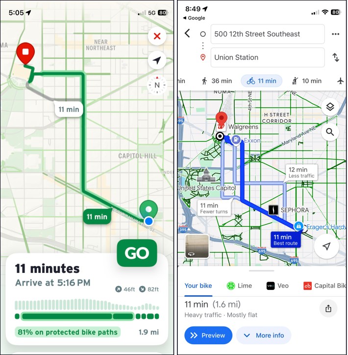
Apple offered directions that led riders from protected bike paths onto Third Street SE, a residential, but busy, street at rush hour. It also suggested a left turn onto Massachusetts Avenue NE.
The riding experience was almost the same with the exception of navigating the busy left turn onto Massachusetts Avenue. Transit app did offer the user additional information, like what percentage of the ride includes protected bike path vs. bike lanes and busy streets. And iconography inside the app lets riders know which road they are using, which can be helpful when making route decisions.
Transit will continue to roll out new updates (audio turn-by-turn directions, for example, are not available yet), which is why real-time feedback from users is critical to make the app usable and accessible for cyclists, Miller said.
“Success is really hearing from people who use the feature to help us make it better,” Miller said. “We have all sorts of ideas for the coming years of how we might want to improve this [app], but it really takes hearing from actual people to help us determine what's the best path forward.”
To let Transit know about any challenges or suggestions with Go Bike, just click here and send a screenshot via. email, or go to Get Support section of the app.
