TransitMix: A New App for Your Fantasy Map
I’m a little intimidated by sharing my first fantasy transit map with an audience that I know to include some ardent and accomplished fantasy transit mappers. But here goes: my first attempt.
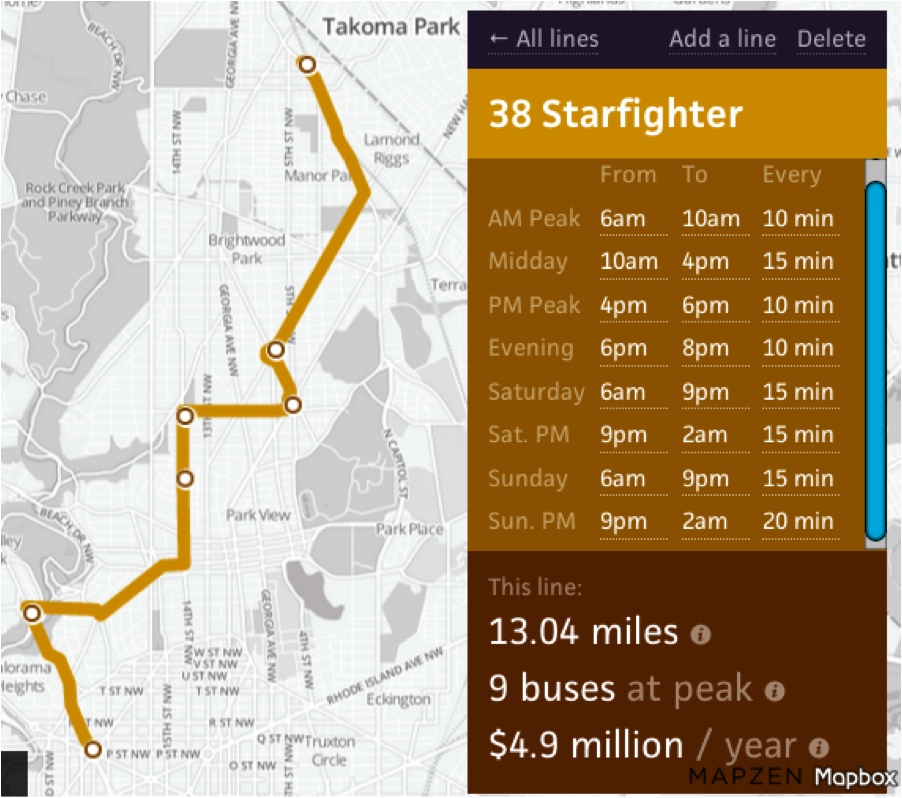
It’s a little circuitous, but it connects neighborhoods that don’t have great connections right now. I didn’t bring it all the way into downtown, which is only another few blocks south, but they’re slow blocks, and everything already connects to downtown. Now that I think about it, I could probably start the route a little south of Takoma Park and shave off a little time. When I increased frequency and weekend night service, the cost jumped. As you can see, I’m beginning to realize the tradeoffs that go into transit planning.
I made this map using Transitmix, a new tool from Code for America. By the way, the route name and number — 38 Starfighter — were their idea, and better than anything I would have come up with.
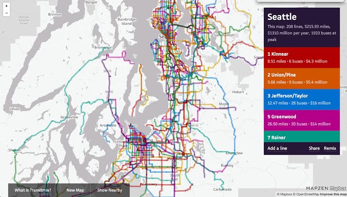
Here’s what a more talented fantasy mapper than myself designed for Seattle:
“We were inspired by last year’s Streetmix,” said Sam Hashemi, a fellow at Code for America. “It was really compelling to be able to move around your block and see the implications of what you’re doing. So the inspiration was to see if we can make [transit planning] a more democratic process, where anyone can just come in and propose a new bus route.”
Once Sam and his team made a quick prototype, they started hearing from transit planners, who said it was a useful tool for them. Often, bus routes are planned by people sketching them out on paper, then putting them into Google Earth to check the mileage, then entering the data into an Excel spreadsheet to see what it costs. Code for America realized they could do better than that.
“There is a lot of useful potential to the tool,” said Renata Silberblatt of the Tri-State Transportation Campaign in her blog post. “Imagine attending a public meeting where participants could collaborate to design bus routes on iPads, or having bus riders design or modify a route while they’re aboard a bus, or redesigning your commute from the comforts of your own home, hitting ‘submit,’ and sending your input directly to your transit agency.”
I probably don’t need to sell you any harder on this really fun and practical tool. You’re already itching to have a go at it. Go play.

Read More:
Streetsblog has migrated to a new comment system. New commenters can register directly in the comments section of any article. Returning commenters: your previous comments and display name have been preserved, but you'll need to reclaim your account by clicking "Forgot your password?" on the sign-in form, entering your email, and following the verification link to set a new password — this is required because passwords could not be carried over during the migration. For questions, contact tips@streetsblog.org.