Could the Strava App Provide the Biking and Walking Data Cities Crave?

Strava may be making the leap from feel-good gadget for hard core exercise buffs to serious planning tool for cities looking to improve active transportation.
Strava is a mobile app that runners and cyclists use to record their activities, track their progress, and see their stats and personal records. Its website shows a bunch of young, fit, white people in performance gear, riding 12-ounce racing bikes in an aggressive position or running through woods with their feet never touching the ground. “Prove it,” seems to be their motto.
Rather than proving bragging rights about your latest personal record, Strava might be able to prove the need for safe cycling infrastructure on a heavily ridden route, or the increase in use since a protected bike lane was installed.
In addition to showing users the maps of their own routes, Strava is now releasing its global data online, creating heat maps of where people run and bike — or at least, where they run and bike with Strava tracking their movements. Users can separate out running and biking — the maps in this article only show biking.
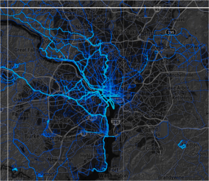
Oregon DOT has caught on to the utility of this information and has become the first state transportation agency to pay Strava for its data. Jonathan Maus at Bike Portland reported yesterday that ODOT has paid $20,000 for a “one-year license of a dataset that includes the activities of about 17,700 riders and 400,000 individual bicycle trips totaling 5 million BMT (bicycle miles traveled) logged on Strava in 2013.”
This data matters, Maus says:
The problem for many transportation agencies today is that, while bicycling is on the rise (for both transportation and recreation), there remains a major lack of data. This gap in data makes it much harder to justify bicycle investments, plan for future bicycle traffic growth, illustrate the benefits of bike infrastructure investments, and so on. It also makes non-auto use of roads very easy for agencies to overlook. And while ODOT and many cities do bike counts already, they only measure one location for a short period of time.
Biking and walking advocates need good baseline data to prove the need for better infrastructure and to measure the benefits once that infrastructure is put in. That data can also help justify similar projects elsewhere. Will the Strava maps fill that need?
It’s hard to say. In all likelihood, Strava is primarily capturing data from recreational cyclists and runners, not people who commute on foot and by bike. Most Strava users probably choose routes for speed more than the convenient access to important destinations. But some utilitarian cyclists use trackers like Strava too, particularly for contests like the National Bike Challenge, which started yesterday. (Some note that they’ve ended up uninstalling it because of battery drain.) And though I don’t have demographic information on Strava users, my guess would be that they tilt wealthier and younger than the overall biking and running population of a city.
Still, the maps could help planners see heavily-cycled routes that are in need of infrastructure or note the streets that cyclists tend to avoid. The baseline data Strava provides would be littered with caveats and disclaimers, but it’s still more than we knew before, and presented in a compelling visual, zoomable to the finest-grain detail.
Other jurisdictions are trying to capture this information without Strava. In 2010, the San Francisco County Transportation Authority created the CycleTracks app that people could load onto their phones to let the city see where they’re going (with personally identifiable information stripped out, of course), what route they took, what the purpose of their trip was, and more. Planners say it’s helped them craft the city’s bike plan, with realistic data about how the city’s bicycle network was being used and what the needs were. Other cities have piggybacked off San Francisco’s success with the app and adopted it for their own use.

Streetsblog has migrated to a new comment system. New commenters can register directly in the comments section of any article. Returning commenters: your previous comments and display name have been preserved, but you'll need to reclaim your account by clicking "Forgot your password?" on the sign-in form, entering your email, and following the verification link to set a new password — this is required because passwords could not be carried over during the migration. For questions, contact tips@streetsblog.org.