Two Maps Show How We Designed Walking Out of the Suburbs
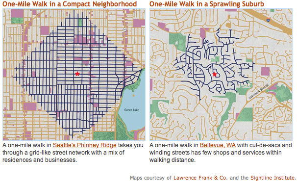
Having a finely grained street grid is incredibly important to walkable communities, as the above graphic from the Sightline Institute demonstrates. These side-by-side maps show how windy, disconnected, suburban streets make it difficult-to-impossible to get around on foot.
This is why Happy City author Charles Montgomery noted in Slate that “cul de sacs are bad for your health.” It’s also why advocates for healthy cities were horrified and amused when Cato Institute “scholar” Randall O’Toole recently suggested turning gridded streets in rust belt cities into cul de sacs “so that criminals have fewer escape routes.” Spending lots of money to ruin the street grid is an absolutely terrible idea, especially in cities struggling to provide basic services to their residents.
As Transport Initiatives, a U.K.-based transportation consultancy, points out, the one-mile walk coverage could be extended even more in the first example by adding some diagonal routes, like the street grids in Chicago and Washington, DC.
Hat Tip to Walk Score on the graphic.

Streetsblog has migrated to a new comment system. New commenters can register directly in the comments section of any article. Returning commenters: your previous comments and display name have been preserved, but you'll need to reclaim your account by clicking "Forgot your password?" on the sign-in form, entering your email, and following the verification link to set a new password — this is required because passwords could not be carried over during the migration. For questions, contact tips@streetsblog.org.