Google Shows That When Transit Agencies Free Their Data, Riders Win
Earlier this week, in a forum about intelligent cities and the ways data can improve urban planning, Carolyn Young of Portland’s TriMet let it slip that Portland was one of the first cities to share its real-time transit tracking data on Google Maps. (Google announced the news two days later.)
For transit agencies, letting Google provide useful transit data to their customers (and the bazillions of other people who log on to Google every day) seems to be a win-win situation, but Young observed that not all agencies feel that way. “There are a lot of barriers,” she said. “Some think, ‘It’s our data, we don’t want to give it to anybody, maybe we can make money with it.’”
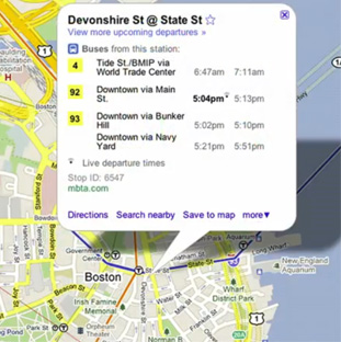
Boston’s MBTA has a different perspective on data-sharing. The agency doesn’t even show real-time tracking on its website – instead it links to an App Showcase of third-party software developers that have created tracking tools on their own.
“We believe very strongly that not only can working with third party developers get information to our riders more quickly, it helps us do it more innovatively, and at a lower cost,” MBTA’s Joshua Robin told Streetsblog. “We started releasing real-time bus information as a pilot back in November of 2009 as part of this big developer conference we had. The first application was developed within an hour. No application developed by a transit agency is going to come out that quickly. You wouldn’t even be in the first stage of any kind of procurement by then.”
There are now more than 30 third-party apps that connect T riders with real-time tracking data – all at no cost to the MBTA. Robin says people almost always get traffic and weather information from a third party like news radio. He sees transit data the same way.
Of course, having Google be one of those third-party hosts is a whole different ballgame. “Millions of people use Google maps to plan their trips every single day,” Robin said. “That is a massive market. Our goal always is to make real-time info about our system as ubiquitous as possible, and working with Google obviously was a big part of achieving that goal.”
It also took a little more elbow grease. While the T always works closely with its app developers, it had to put in some significant programming work to get the data to match Google’s system.
Google came up with a standard format for all of the agencies’ real-time transit data. The company took its data format, called GTFS, or General Transit Feed Specification, which has become the “de facto standard” for schedule information, according to Robin, and modified it for real-time tracking. The T was already using GTFS for schedule information but had some re-programming to do to put the tracking data in that format.
Besides Boston and Portland, San Diego, San Francisco, Madrid and Turin were part of Google’s initial rollout of real-time tracking data.
Stay in touch
Sign up for our free newsletter
More from Streetsblog USA
Thursday’s Headlines Are Down on Highways
Two outlets recently featured articles on the harmful effects of ongoing freeway projects.
Talking Headways Podcast: Details of Development Reform in Minnesota, Part I
Jim Kumon of Electric Housing discusses his work as a developer and urban policy educator in the Twin Cities.

Thursday’s Headlines Don’t Like Riding on the Passenger Side
Can you take me to the store, and then the bank? I've got five dollars you can put in the tank.

Study: When Speed Limits Rise on Interstates, So Do Crash Hot Spots on Nearby Roads
Rising interstate speeds don't just make roads deadlier for people who drive on them — and local decision makers need to be prepared.

Calif. Bill to Require Speed Control in Vehicles Goes Limp
Also passed yesterday were S.B 961, the Complete Streets bill, a bill on Bay Area transit funding, and a prohibition on state funding for Class III bikeways.