From Challenge to Opportunity: Transforming Salt Lake City’s Wide Streets

Editor’s note: this article is an excerpt from the Vision Zero Cities Journal and is republished with permission. For more information on the Vision Zero Cities 2024 conference, click here.
Salt Lake City’s urban form, while common in Utah and found elsewhere in the Western United States, is characterized by an unusually large grid pattern of 132-foot wide streets and 660-foot square blocks.
When Brigham Young and city founders laid out the street and block system in 1947 using Joseph Smith’s “Plat of Zion” as their model, they envisioned a utopian agricultural settlement with each block intended for just eight families. Streets were meant to serve many functions like water conveyance for irrigation of crops, pedestrian travel, and use by large teams of oxen.
Compared to cities like Portland, Oregon, which has blocks only 200 feet in length and support pedestrian activity by design, Salt Lake City’s blocks are impractically long and its car-dominated streets are dangerously wide. The large block structure limits pedestrian circulation, with fewer and less-direct routes to choose from. An inconsistent system of mid-block streets and alleys pushes pedestrians to the main streets, where driveways and vehicle access interrupt sidewalks and bike lanes. People are forced to cross wide roads — often six or more lanes — and the expansive streets encourage cars to drive at dangerous speeds.
As the metro population grows, welcoming 44,000 new residents in 2022 alone, its street design continues to affect safety and public life even as parts of the city densify and the demand for walkable and bikeable places increases.
While this urban form presents a massive challenge to walkability and bikeability, it paradoxically represents a rare opportunity for transportation planners and urban designers. Narrow streets in other cities restrict the number and width of amenities requiring tradeoffs. Salt Lake City’s wide streets and long blocks allow for a light rail system, called TRAX, to operate freely without needing to share lanes with vehicle traffic as is common with other on-street rail networks. They allow for generous 20-foot wide sidewalks on both sides of Main Street, which provide ample room for pedestrians and sidewalk dining. Salt Lake’s cycle tracks — buffered bike lanes that are sometimes grade-separated — allow for safe, high-comfort bike travel across town and are wide enough for plows to navigate in winter.
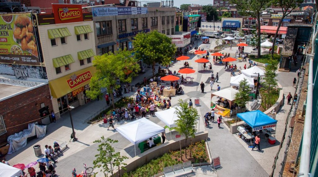
As the downtown has densified, finding space to develop traditional parks with large expanses of landscaped recreation areas has presented financial and land availability challenges. Salt Lake City has begun to imagine its streets as not just space for cars, but as ecologically resilient, green, social spaces that can accommodate all modes. The city is working to convert travel lanes to green space, thus making the streets safer for all users.
Salt Lake City’s Vision Zero Commitment
On January 11, 2023, Mayor Erin Mendenhall announced Salt Lake City’s commitment to becoming the first Vision Zero city in Utah, with the goal of achieving zero fatalities and serious injuries on city streets by 2035. This milestone marks a shift from the city’s previous strategy of selectively implementing active mobility infrastructure only when it didn’t impact vehicular traffic.
Even before the adoption of Vision Zero, city leadership was working towards a more pedestrian- and bike-friendly downtown Salt Lake City. First envisioned by the downtown business improvement district, the 2016 Downtown Plan proposed a “Green Loop” to encircle the downtown, creating a linear park on surface streets and connecting it to trail and park systems. This plan acknowledged downtown as a growing neighborhood, with 15,000 additional residents expected by 2040, and recognized that city-owned streets represent the greatest possibility to fulfill these residents’ needs for parks and green space. Downtown growth came quickly and is expected to exceed this population target by 2025.

The development of the Street and Intersection Typologies Design Guide in 2020 was a critical milestone towards the launch of the Green Loop project. Led by the Transportation Division, this design guide recommends street designs that align with community context, including lane reductions and changes to street parking, and repurposing the right-of-way for people, bikes, and green infrastructure. The guide provides a set of guidelines for implementing traffic calming elements, bike lane typologies, bus stops, and myriad other elements that make streets work.
The Street and Intersection Typologies Design Guide defines a transportation identity for each street type in the city: transit streets, bike-oriented, and pedestrian-oriented. By categorizing street types based on shared characteristics, the guide helps optimize decision-making, ensures consistency, addresses functional needs, and helps transportation planners respond to contextual and cultural factors.
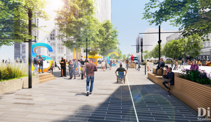
Residents demonstrated support for street reconstruction in 2018 by funding a bond initiative to implement street redesigns and routine repaving work. This has resulted in the rapid deployment of numerous permanent, physical traffic calming elements throughout Salt Lake City: protected intersections for cyclists; intersection daylighting for safer pedestrian crossings; rebuilding streets to meet Complete Streets objectives; studying Main Street’s potential transformation into a pedestrian mall; and implementation of the 9 Line Trail, a 3.5-mile enhanced trail and sidewalk system that reconfigured travel lanes and connects the east and west sides of the city. The Green Loop is expected to be the gem of the system, running on roads with the “Urban Green Street” typology.
While new park space has been hard to come by, Salt Lake City’s streets, comprising 30-35% of the city’s land area, are an obvious choice for building new parks. By reconfiguring excess vehicular capacity on the identified streets, Salt Lake City aims to bring nearly fifty-four acres of new parkland along the 5.5-mile corridor — almost tripling the park acreage downtown without purchasing a single property. The Green Loop is expected to serve as the principal recreation spine for a fast-growing urban neighborhood.
Lessons Learned
The successful transition of streets to multimodal linear parks requires strong collaboration across multiple city departments to address diverse needs and challenges. Determining project ownership presents an early challenge for effective leadership and sourcing funding. Each city department has a stake: public utilities have an interest due to the integration of green stormwater management solutions, while the transportation department may lead because of the inclusion of bike and pedestrian facilities aimed at improving safety. Urban design plays a key role, given the project’s focus on creating safe, vibrant spaces that support economic development and address ecological concerns like urban heat islands. Meanwhile, the parks department has a valid claim since the project ultimately adds new parkland to the city. Conflicts will arise between project partners, emphasizing the need for leadership that understands how to balance objectives. For instance, prioritizing the placement of trees before utilities, when possible, ensures optimal outcomes above ground.
Public optics are another important consideration when it comes to project costs. Unlike in cities with narrow streets with utilities stacked vertically, in Salt Lake City, the wide streets lend themselves to unconstrained placement of utility lines, which have often been spread horizontally across the right-of-way. This presents limitations to tree planting and other above-ground features. Utility relocation represents the biggest price tag but often goes unseen by the community who are left wondering why a park costs so much. Framing the project as a coordinated public utility, transportation, urban design, and park project communicates the complexity of the project and informs public perception.
Projects of this scale — the Green Loop’s 5.5 miles of linear park on city streets, or the prioritization of the pedestrian experience on Main Street — are unprecedented in Salt Lake City. More remarkable is the enthusiasm among residents for projects that promise to redefine city streets as active, people-centered landscapes that keep people safe and improve the city’s livability. Salt Lake City’s rapidly growing population — adding 22,000 residents between 2022 and 2023 — further underscores the importance and urgency of this transformation. Named a cornerstone of her mayoral agenda, Mayor Mendenhall committed to the Green Loop’s completion in time for the city to host the 2034 Winter Olympic Games, when Salt Lake City will capture the world’s attention. With a dedication to Vision Zero goals, downtown will be recognized as a place that supports urban life.


Streetsblog has migrated to a new comment system. New commenters can register directly in the comments section of any article. Returning commenters: your previous comments and display name have been preserved, but you'll need to reclaim your account by clicking "Forgot your password?" on the sign-in form, entering your email, and following the verification link to set a new password — this is required because passwords could not be carried over during the migration. For questions, contact tips@streetsblog.org.