Vote for the Best Urban Street Transformation of 2015
It’s almost time to say goodbye to 2015, which means we’re about to hand out Streetsies to recognize achievements for walking, biking, and transit in American cities this year.
Earlier this month we asked readers for nominations for the Best Urban Street Transformation of the year, and here are the standouts from your submissions. It’s a great batch and all of these cities deserve recognition for claiming space from cars and devoting it to people. But only one can win! Your votes will determine who gets the honor.
Here are the nominees:
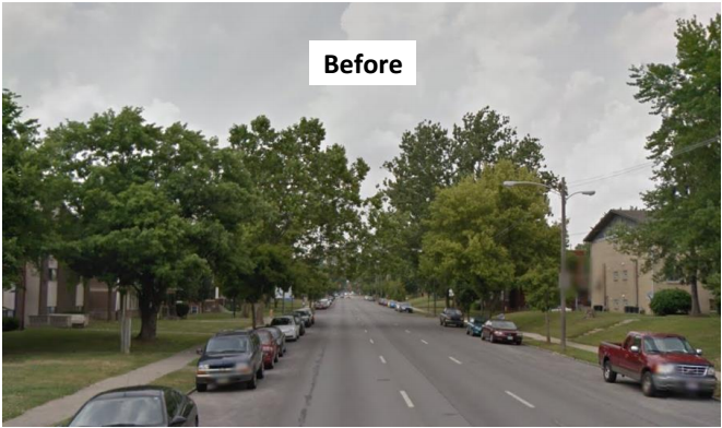
Chicago: Washington Street
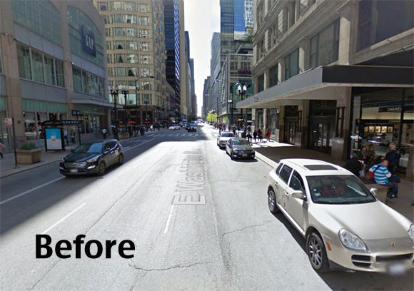
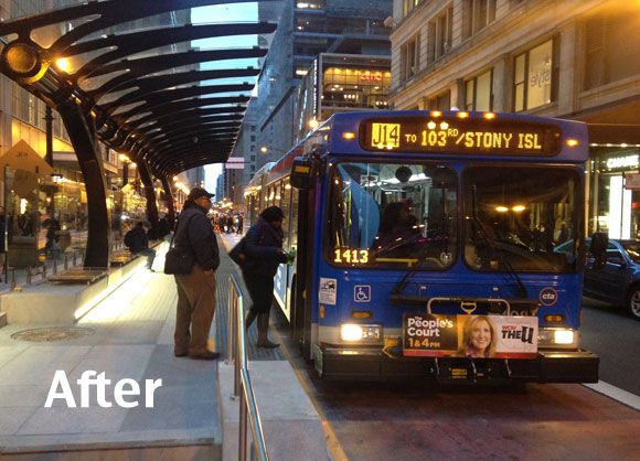
Chicago DOT’s redesign of Washington Street, part of the “Loop Link” bus rapid transit corridor, is the most multi-modal entrant this year.
Following last Sunday’s launch, six bus lines now bypass heavy congestion in dedicated lanes on mile-long stretches of Washington and Madison streets, which connect commuter rail and Amtrak stations in the West Loop to Michigan Avenue. The project includes eight “near-level” bus boarding platforms with rain canopies and seating. Queue-jump signals give buses a head start over car traffic, and off-board fare collection will be piloted next year.
On Washington, between the island bus stations and the curb, there’s a new protected bike lane, providing an important link in the city’s bicycle network. The Washington redesign repurposed an impressive share of street space on what had been a five-lane street, claiming three lanes that were used for motor vehicle movement and parking. If Loop Link proves successful, advocates hope the city will follow through with tentative plans for a more robust BRT corridor on a 16-mile stretch of Ashland Avenue, a north-south street located two miles west of the center of town.
Columbus: Summit Street
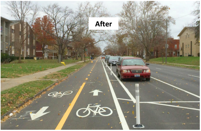
Summit Street is near Ohio State University’s campus, not far from downtown Columbus. Scott Ulrich, the city’s bicycle planner, writes that the Ohio Department of Transportation was getting ready to resurface the road when the city stepped in.
Initial traffic studies and public involvement indicated that these streets had excess capacity, speeding problems and low safety perceptions for walking, biking and people waiting for buses.
The City of Columbus, in partnership with local bike advocacy group Yay Bikes!, decided to take advantage of the resurfacing project as an opportunity to redesign the street to re-allocate space more equitably.
The project repurposed one traffic lane to create a parking-protected two-way bike lane and bus bulbs. It calmed a dangerous, high-speed one-way route through a huge residential college campus with lots of walking (including much walking that’s a little wobbly). In addition, it connects a dense, growing residential area (Campus, the Short North) to downtown with high quality bike lanes, making it an ideal commuter bike route.
Los Angeles: Reseda Boulevard
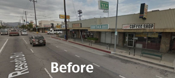
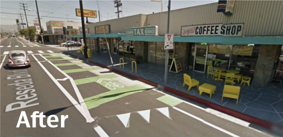
This project includes L.A.’s first ever parking-protected bike lane. Called [RE]visit [RE]seda, the redesign was planned by a partnership between a number of community groups in the Northridge area. In addition to the bike lane, the project also includes the yellow sidewalk furniture you can see above, as well as sidewalk painting designed to draw people to seating by the businesses, according to Semee Park, a staffer for local Council Member Mitchell Englander. The neighborhood also received a challenge grant from ioby (“in our backyards”) to program events along the corridor. A survey after the project was completed found 97 percent of respondents thought the project helped foster a sense of community.
New York City: Queens Boulevard
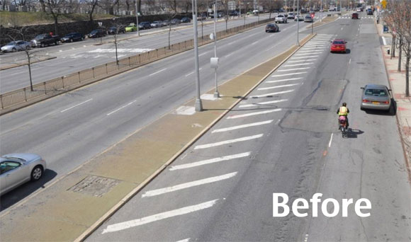
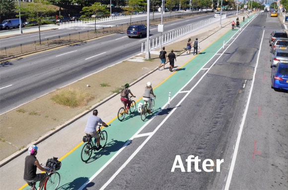
With its redesign of 1.3 miles of Queens Boulevard, NYC DOT has started to humanize one of the most heavily motorized streets in New York. Queens Boulevard is a surface level highway funneling traffic to and from Manhattan. It has long been known as the “Boulevard of Death” for its horrific rate of fatalities and injuries. In 2008, after her son Asif was killed while biking on the street, Lizi Rahman began campaigning for a bike lane on Queens Boulevard. This is the year the city took action.
The project repurposed unused space on the boulevard’s service roads to carve out room for a green bike lane separated from traffic by plastic posts. In addition, several “slip lanes” that drivers could use to merge at high speed between the central roadway and the service roads were filled in, reducing conflicts and expanding pedestrian space. Other slip lanes were squared off to compel drivers to come to a complete stop instead of merging at speed. Much more of Queens Boulevard needs to be redesigned to make the whole corridor safer for biking and walking, but this is the project that proved it can be done. And if it can be done on Queens Boulevard, it can be done anywhere.
Salt Lake City: Protected Intersection at 200 West and 300 South
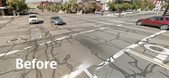
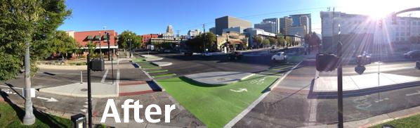
Salt Lake City became just the second American city to construct a Dutch-style protected intersection, about two months after Davis, California.
Intersection design is especially important in Salt Lake City, given its notoriously wide streets. The protected intersection helps motorists, cyclists, and pedestrians all see each other and stay clear of each other’s paths.
SLC Transportation Director Robin Hutcheson told CityLab the city was planning a protected bike lane along 300 South and was looking for a solution to keep cyclists safe at the intersection:
We looked at the entire range of possibilities, and this just made so much sense. We know that ‘protected’ is what people are asking for. It creates safety and comfort. We have the space.
The project was based on a design promoted by Alta Planning’s Nick Falbo, who was inspired by similar Dutch designs.
Seattle: University, Union, and Boylston Pedestrian Plaza
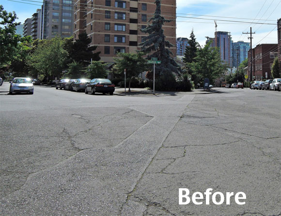
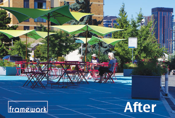
This project was one of two “pavement parks” initiated by a community group in Seattle’s First Hill neighborhood. Gordon Werner, who nominated them, says they were designed to slow drivers and respond to the pressing need for public gathering places:
Seattle’s First Hill neighborhood is a dense urban community home to high rise residential building, major medical institutions, educational, and commercial uses — and a scarcity of public open space. Rising land values and development pressures have made acquiring traditional space for a new park difficult. So, in 2014, the First Hill Improvement Association partnered with three city agencies — SDOT, DPD, and Parks- to explore a concept sweeping the country: repurposing land in the public right of way from pavement (especially awkward public intersections or overly broad streets) into new uses as community gathering areas — pavement parks!
Through the First Hill Public Realm Action Plan, two pilot pavement parks were created on First Hill: one at University Street and 9th Avenue, the other at the intersection of University, Union, and Boylston (UUB). The first of their kind in Seattle, these pavement parks have been embraced by the First Hill community, and function as a public living room for many residents. Particularly at UUB site [pictured above], it’s common to see small gatherings of people sitting, talking, eating, and enjoying themselves outdoors in what had formerly been an unsafe five leg intersection. These spaces accomplish the two fold mission to improve vehicular and pedestrian safety, and to provide community gathering spaces.
There you have it. On to the voting…

Read More:
Streetsblog has migrated to a new comment system. New commenters can register directly in the comments section of any article. Returning commenters: your previous comments and display name have been preserved, but you'll need to reclaim your account by clicking "Forgot your password?" on the sign-in form, entering your email, and following the verification link to set a new password — this is required because passwords could not be carried over during the migration. For questions, contact tips@streetsblog.org.