Smart Growth America: Sprawl Shaves Years Off Your Life
Want to live a long, healthy, prosperous life? Don’t live in sprawlsville.

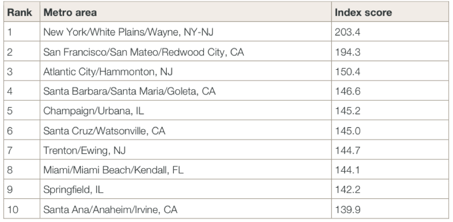
Atlanta, I'm looking at you. Nashville, you too. Southern California's Inland Empire: ouch. Meanwhile, break out the bubbly if you live in Atlantic City, Urbana/Champaign, or Santa Cruz -- which all rank close to giants like New York and San Francisco as some of the most compact and connected metro areas in the U.S. That compact development brings a bounty of benefits you might not associate with those places.
That’s the lesson from Smart Growth America’s new report, “Measuring Sprawl 2014,” an update of their 2002 report, "Measuring Sprawl and Its Impact."
A team of researchers gave a development index score to each of 221 metropolitan areas and 994 counties in the United States based on four main factors: residential and employment density; neighborhood mix of homes, jobs, and services; strength of activity centers and downtowns; and accessibility of the street network. These are the essential buildings blocks of smart growth.
Based on those factors, the most compact and connected metro areas are:
Now, let me defend my hometown -- Washington, DC -- and all the other cities that may have gotten an unfair shake. SGA notes that where it examined metro areas instead of counties, results got a little funky. After all, the DC metro area contains 16 counties, going way outside the city, while Detroit's metro area includes only Wayne County. The upshot is that the DC area ranks 91st on the index based on its metro area while it ranks sixth based on its county.
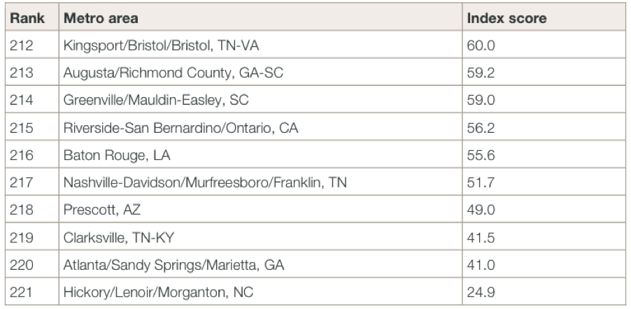
But DC is still not anywhere close to placing on this list of most sprawling metros:
Take a close look at those index scores. They mean more than you may think.
For every 10 percent increase in the index score at the metro level, there is:
- a 4.1 percent increase in economic mobility, or the probability that a child born to a family in the bottom quintile of the national income distribution reaches the top quintile of the national income distribution by age 30
- a 1.1 percent increase in housing costs relative to income -- but a 3.5 percent decrease in transportation costs relative to income. That means the combined costs of housing and transportation fall when communities become more compact. Households in the worst-ranked Hickory, North Carolina, spend a whopping 29 percent of their income on transportation, about two-and-a-half times the percentage San Franciscans spend
- a 3.9 percent increase in the walk mode share
- an 11.5 percent increase in the transit mode share
Surprisingly, the higher rates of walking and transit use in compact places don't seem to translate to a proportional decline in driving. SGA found just a 0.6 percent decline in vehicle ownership and a 0.5 percent decline in driving time for every 10 percent bump in index score.
At the county level, for every doubling in the index score, life expectancy increases by about 4 percent, or about three years.
A whole host of health and safety risks factor into the link between sprawl and life expectancy. For one, the risk of a fatal collision rises with sprawl. “Counties with less sprawl have more car crashes,” the authors write, “but fewer of those crashes are fatal. For every 10 percent increase in the Index, fatal crashes decrease by almost 15 percent.”
Obesity and body mass index, blood pressure and diabetes also rise with sprawl. Air quality worsens.
Communities can change their built environment and all the health and economic indicators that go with it. They can enact zoning codes to encourage mixed use development, like Santa Barbara did. They can promote downtown residency and reinvestment in existing housing stock, like Madison. They can follow Los Angeles’s example and jumpstart development around transit stations, increasing allowable density and reducing parking requirements in those places.
Density isn’t destiny -- unless communities do nothing to change.
Stay in touch
Sign up for our free newsletter
More from Streetsblog USA
Thursday’s Headlines Don’t Like Riding on the Passenger Side
Can you take me to the store, and then the bank? I've got five dollars you can put in the tank.

Study: When Speed Limits Rise on Interstates, So Do Crash Hot Spots on Nearby Roads
Rising interstate speeds don't just make roads deadlier for people who drive on them — and local decision makers need to be prepared.

Calif. Bill to Require Speed Control in Vehicles Goes Limp
Also passed yesterday were S.B 961, the Complete Streets bill, a bill on Bay Area transit funding, and a prohibition on state funding for Class III bikeways.
Under Threat of Federal Suit (Again!), NYC Promises Action on ‘Unacceptable’ Illegal Police Parking
A deputy mayor made a flat-out promise to eliminate illegal police parking that violates the Americans With Disabilities Act. But when? How? We don't know.
Legendary Chicago bicycle traveler and writer George Christensen killed by truck driver in South Carolina
As a longtime bicycle courier, and one of Chicago’s most adventurous bike riders and writers, George Christensen did extensive cycling trips in Africa, Asia, Australia, Europe, North America, and South America. Learn more about his legacy.